
This chapter explains and analyzes GNSS related knowledge, starting from the basic knowledge, comparison of positioning systems, how to debug during the development process, and what to pay attention to in the design. The general content will be explained through several articles.
The main knowledge points of this chapter are based on the basics. It is not difficult and will be able to solve the following problems:
An overview of some GNSS terms,
What are some positioning principles of GNSS?
Several common systems in the GNSS system, and the comparison. What is the relationship between GNSS and GPS?
What are the outstanding advantages of the Beidou system?
Special terms:
GEO (geostationary orbit) – geostationary orbit, orbital altitude is about 400-2000 kilometers
MEO (Medium Earth Orbit,) – medium earth orbit
GSO (Inclined Geosynchronous Orbit) – inclined geosynchronous orbit
1. GNSS Overview
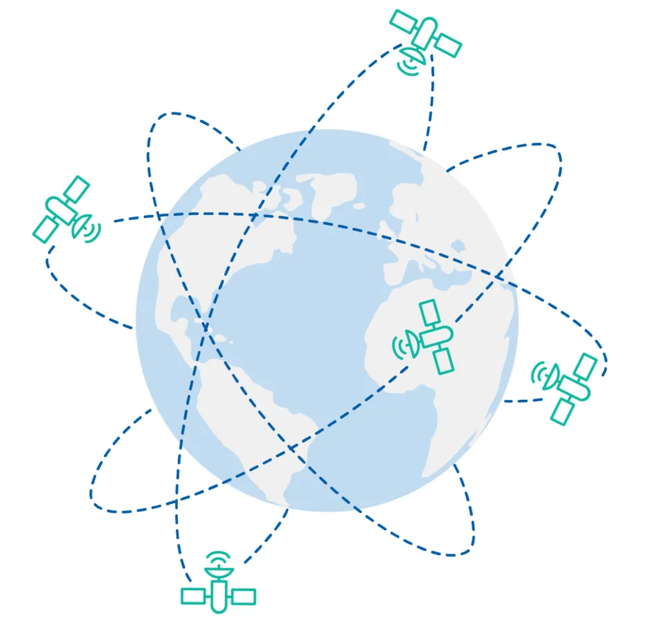
GNSS (Global Navigation Satellite System) is a satellite system with global coverage used to determine the precise position of any point on Earth. For global coverage, it is estimated that a constellation of 18 to 30 satellites is needed. Navigation satellites provide orbital information and accurate timing (and other services) to radio receivers specially designed to receive signals from these satellites and decode the signal message content. Using the message content from at least four “visible” satellites, the position of most locations on or near the Earth’s surface can be calculated using a mathematical process called trilateration.
GNSS mainly includes:
GPS (originally Navstar GPS)- United States
BeiDou – China
Galileo – European Union
GLONASS – Russia
It should be noted here that GPS is a type of GNSS, and the BeiDou satellite navigation system used in my country is also a type of GNSS. There are global satellite navigation systems, and some are regional navigation satellite systems RNSS (regional navigation satellite systems), currently represented by:
IRNSS – India (also known as NavIC)
QZSS – Japan
1.1 Main functions of GNSS
GNSS is developed for two main functions:
Location determination: The location of an object refers to latitude, longitude, and altitude.
Time synchronization: Since GNSS satellites use high-precision clocks, GNSS receivers will synchronize their internal (much less accurate) clocks with the satellite clocks.
GNSS satellites use atomic clocks, which contain elements such as hydrogen, rubidium, and cesium. This type of clock is very stable, with an error of one second in 20 million years. Among the four major satellite navigation systems in the world, the US GPS uses a combination of cesium and rubidium atomic clocks. The European Union’s Galileo, Russia’s third-generation GLONASS, and my country’s BeiDou-3 all use a combination of rubidium atomic clocks and passive hydrogen atomic clocks for time synchronization.
1.2 Overview of the Four Major GNSS
1.2.1 GPS
The Global Positioning System (GPS) is managed by the US government and is the earliest and most famous GNSS system. It was originally used as a positioning and location system for military purposes, and later GPS was opened to civilian and commercial use. There are a total of 24 satellites that can provide global coverage. It is the oldest and most mature global satellite navigation system currently in use.
1.2.2 BeiDou
The BeiDou Navigation Satellite System, also known as BSD (BeiDou Navigation Satellite System), also has another English name: Compass (China Satellite Navigation System). It is a satellite navigation system independently developed by my country, which can provide all-weather, all-day, high-precision positioning, navigation and timing services to the world. There are three generations of BeiDou system development. Since the second generation, the BeiDou system is officially called “BeiDou Satellite Navigation System”.
BeiDou-1 system (first generation BeiDou system) provides regional positioning services by three satellites. Since 2000, the system has mainly provided navigation services in China.
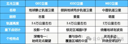
BeiDou-2 system (second generation BeiDou system) is a global satellite navigation system consisting of 16 satellites, including 6 geostationary orbit satellites, 6 inclined geosynchronous orbit satellites, and 4 medium earth orbit satellites. In November 2012, the second generation BeiDou system began to provide regional positioning services to users in the Asia-Pacific region. The several satellite orbits mentioned here are summarized as follows:
The BeiDou-3 system (the third generation BeiDou system) consists of satellites in three different orbits, including 24 medium earth orbit satellites (covering the world), 3 inclined geosynchronous orbit satellites (covering most of the Asia-Pacific region) and 3 geostationary orbit satellites (covering China)[6]. BeiDou-3 opened the global positioning function of the BeiDou system ahead of schedule in 2018. The BeiDou-3 system was fully launched on July 31, 2020.
1.2.3 GLONASS
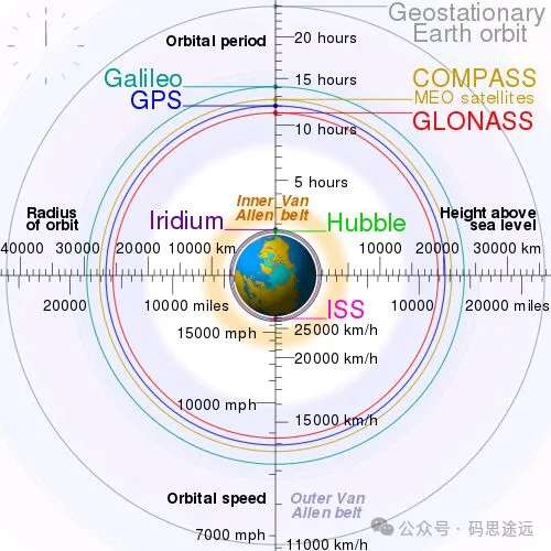
GLONASS system (abbreviation of GLOBAL NAVIGATION SATELLITE SYSTEM) consists of 21 working satellites and 3 backup satellites, so the GLONASS constellation consists of 24 satellites in total. The 24 satellites are evenly distributed on 3 nearly circular orbital planes, which are 120 degrees apart from each other. Each orbital plane has 8 satellites, and the satellites in the same plane are 45 degrees apart. The orbital altitude is 23,600 kilometers, the operating cycle is 11 hours and 15 minutes, and the orbital inclination is 64.8 degrees.
1.2.4 Galileo
Galileo is a European global navigation satellite system developed and operated by the European Space Agency (ESA) and the European Union. Galileo aims to provide global positioning services as a supplement to the existing GNSS system. The system is independent of Russia’s GLONASS and the United States’ GPS. When these systems are shut down, the European Union can use the Galileo system. The system plans to launch 30 satellites. As of July 2018, 26 satellites have been launched into orbit. The Galileo system held an activation ceremony in Brussels on December 15, 2016 to provide early services. Initial working services will be provided from 2017 to 2018, and full working capabilities will be achieved in 2019. The system’s 30 satellites are expected to be launched by the end of 2020, including 24 working satellites and 6 spare satellites.
1.3 Comparison of major GNSS systems
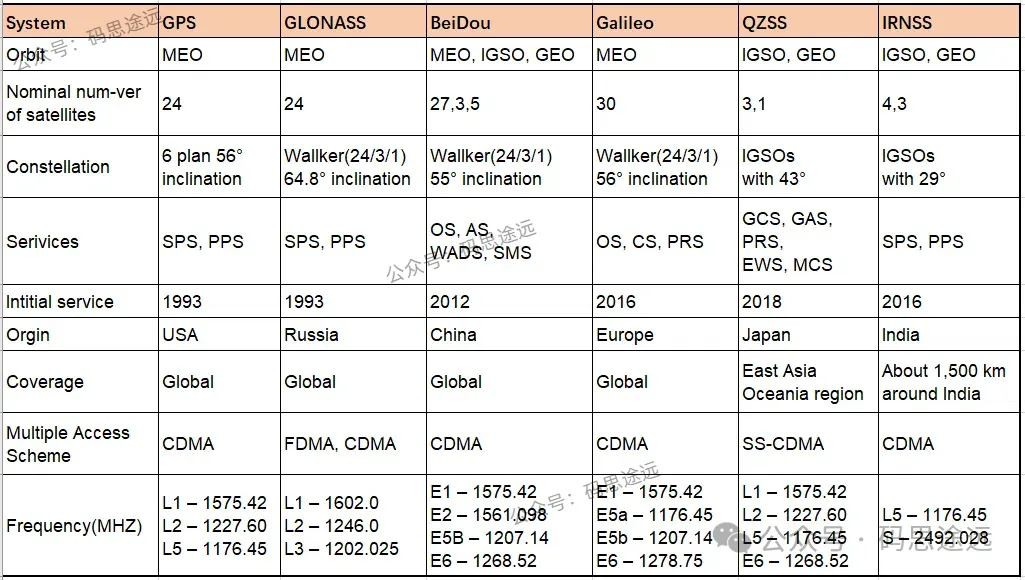
From the table, we can clearly see some parameters about the major positioning systems.
These satellite positioning systems are located at different altitudes, including medium earth orbit (MEO), geosynchronous orbit (GEO), geostationary orbit (GEO), inclined geosynchronous orbit (IGSO); the two external inclination angles are also different, and the frequency bands they work in are different, so there will be some changes. If the frequencies are very close, it will be a test for the signal processing and receiving wires in the receiver module. Beidou has a special application called short message, which can be understood as using satellites for data transmission.
From the table, the Beidou global positioning system has the largest number of satellites, reaching 35, one for accuracy, coverage, and redundancy.
Here is a small question: As of press time (2024-8-11), according to official website data, my country has successfully launched the 57th and 58th Beidou navigation satellites. So why is Beidou only using 35 satellites for positioning now?
2. GNSS system architecture
How is the GNSS system designed and what are the main components required to achieve a positioning function.
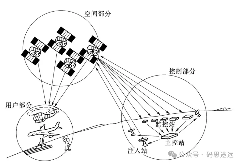
GNSS system mainly consists of three parts: space part, control part and user part. Most people are more exposed to the user part, whether it is used for positioning or development.
Space part: mainly positioning satellites, such as GPS satellites and Beidou satellites. It also has several atomic clocks inside to ensure the accuracy of time, and will continuously send signals to the ground.
Control part: The ground station is the control center of the satellite and also the monitoring center. It needs to monitor the working status and health of the satellite, and can also control the satellite.
User part: used by user devices such as mobile phones, navigation equipment, positioning on airplanes, etc.
- Introduction to positioning principle
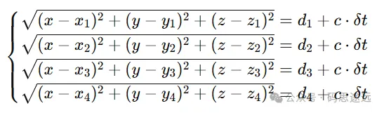
If you want to know the location of the receiver, you need to track at least three satellites simultaneously to locate it. Considering the clock error of the receiver clock, at least four or more satellites are needed for positioning.
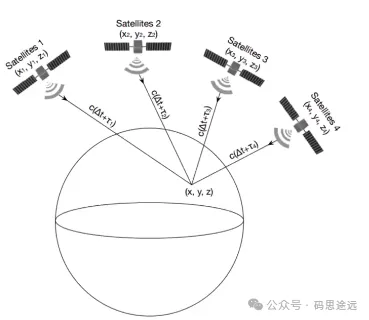
The positioning principle is relatively simple: the receiver is regarded as a point A, and the satellite coordinates are known X, Y, Z. Then draw a circle with the distances x, y, and z from the three satellites to point A. There must be three spheres compared to the two points, so that the receiver A can be quickly determined. For x, y, and z, we can get it by multiplying the light beam by the time. This distance can be calculated, but in this process, we need to take into account that the time of the receiver and the satellite is usually not synchronized, so we need to calculate an unknown clock difference. In order to calculate this clock difference, we need to introduce a fourth satellite to solve this calculation group:
3. Conclusion
This chapter will give an overview of the global satellite positioning system, including a summary of some parameters of the four major GNSS, a unique message function of my country’s Beidou satellite navigation system, the system structure of GNSS, and a simple introduction to the principle of positioning. Although the positioning principle is simple, there are still some columns involving other contents in the middle. The next chapter will describe the principle-related contents, and I also want to share them in the most easy-to-understand way. For embedded development and design, the most is the receiver part, including design, development and application, and debugging, which is probably the part that most people are more concerned about.